Climate change is transforming our world. Unfortunately, efforts to respond appropriately to these threats are hampered by inadequate information about the current and future state of the Earth. In order to develop the best solutions, we must have the proper tools to «read» the earth’s surface with great precision. Researchers at the Universität Zürich (UZH) are applying their vast experience and the latest technology to make this possible.
Climate change and human intervention in nature are accelerating the transformation of ecosystems to an unforeseen extent. Currently, researchers gather information about the state of Earth’s ecosystems through a combination of on-site surveys and aerial observations, so-called remote sensing.

On-site measurements can precisely gauge how nature is changing and adapting to new conditions; however, they are very time- and resource-intensive and can be applied only to small areas. Remote sensing, using equipment mounted on airplanes or satellites, can provide a good overview of large areas, especially those that are difficult to access; this type of measurement can also be done more often to keep pace with the rapid change in ecosystems. However, until now, it was difficult to combine these two methods with a degree of precision, speed and informed analysis that is necessary to develop appropriate solutions.
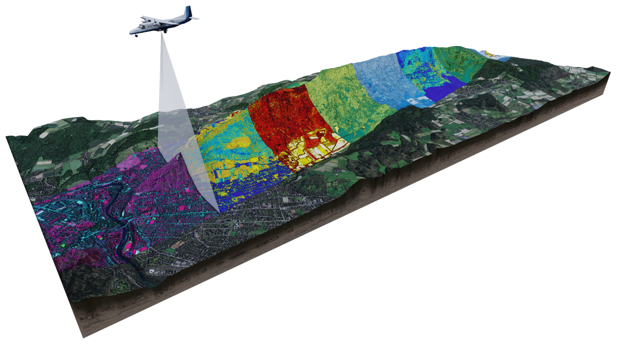
The Airborne Research Facility for the Earth System, ARES for short, is a planned research and application project at UZH. Using the latest remote sensing and information technologies, combined with University researchers’ expertise in biology and chemical ecology, ARES will make it possible to measure various parameters of the terrestrial Earth system - for example, biodiversity or functional processes like chlorophyll production – on a regional scale. In addition, ARES provides a degree of detail, accuracy and data resiliency that will enable the most reliable forecasts of natural processes.
The data obtained and processed through ARES, supported by the expertise of UZH researchers, may be used to support the health of the planet through the measures most appropriate to each location – for example, through removal of carbon from the atmosphere, protecting endangered plants and animals, or developing biodiverse landscapes. Thus ARES provides not only a crucial basis for further scientific investigations, but also serves policy, environmental, natural resource and risk management decision makers.
«Our expertise in flight missions coupled with the broad knowledge of UZH researchers puts our project team in an excellent position. Thanks to your support, we can provide the best information possible to investigate how the Earth system is evolving.»
Dr. Andreas Hüni, ARES Team Leader
UZH is one of the world’s leading institutions in the fields of ecology and remote sensing. Likewise, it currently has the best equipment for measuring various aspects of the Earth’s functions, such as biodiversity, giving it a research edge of several years. Through the cooperation and investment of the ARES project partners ( e.g. NASA ), the project has already obtained a world-class spectrometer identical to that used on the International Space Station. However, more remains to be done to realize the ARES project, through acquisition of additional precision measuring devices, the development of data models and computer processes, and the testing of airborne research methods through flying missions. Financial support is needed to make these possible.
Support the most innovative approaches to remote sensing and ecology and contribute to the preservation of the Earth for future generations. I look forward to hearing from you and will be happy to introduce the ARES project to you personally.
